Yellowstone Caldera Chronicles is a weekly column written by scientists and collaborators of the Yellowstone Volcano Observatory. This week’s contribution is from Michael Poland, geophysicist with the U.S. Geological Survey and scientist-in-charge of the Yellowstone Volcano Observatory.
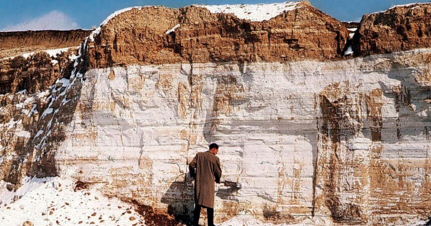
In the late 1800s, geologists studying the Great Plains region of the United States puzzled over strange deposits. For example, a “white, flour-like earth” in Nebraska. Although initially thought to be from nearby hot springs, under the microscope it was determined that these deposits, which could be found across the region, were from volcanic ash that had rained down from some huge prehistoric eruption.
Some of the deposits came to be known as the “Pearlette volcanic ash” based on a description of conspicuous, silver-gray ash beds sitting atop river and lake sediments near the long-since abandoned Pearlette post office, about 22 kilometers (14 miles) north of Meade, Kansas.
Deposits like the Pearlette volcanic ash are important stratigraphic time markers. Stratigraphy is the study of geologic sequences, or strata, and their relation to the geologic time scale. Volcanic ash is especially useful in stratigraphy because it marks an instantaneous event that can be dated and therefore help with understanding the formation times of various geologic units that lie above and below. For example, the Mazama Ash, from the eruption that formed Crater Lake, Oregon, about 7,600 years ago, is found in cores of sediment from the bottom of Yellowstone Lake and can help to determine the ages of hydrothermal explosions in the Yellowstone region.
Initially, the Pearlette volcanic ash was thought to represent a single event. In the 1950s, however, USGS geologist Howard Powers — a volcanologist with significant experience working in Hawaii and who would serve as scientist-in-charge of the Hawaiian Volcano Observatory in the 1960s — examined the chemical and compositional makeup of the ash beds. His work suggested the Pearlette volcanic ash was more widespread than previously thought, not only across the Great Plains, but also as far west as Nevada, and that it might represent multiple chemically distinct events.
In the 1960s, technological innovations in measuring the chemical makeup of rocks allowed USGS geologists Ray Wilcox and Glen Izett to identify at least three distinct ash-fall beds within the Pearlette volcanic ash. Another USGS geologist, Charles Naeser, worked on dating the ash beds in the 1970s by examining the zircon crystals they contained, confirming there were indeed three ash layers. Various dating techniques, including examination of the magnetization of the ash beds and correlating that to the Earth’s changing magnetic field over time, ultimately determined the three layers had ages of about 2.1, 1.3, and 0.6 million years.
But what was the source of the ash? In the first part of the 1900s, speculation centered on northwest New Mexico, perhaps from the Capulin volcanic cluster, based on the prevailing wind direction. These volcanoes differ in composition from the Pearlette ash, so the Jemez Mountains, home to Valles caldera and its thick ash flow deposits, were considered. But the chemistry of the Pearlette ash did not match, nor did it match that of ash from Long Valley caldera, in Eastern California. That left the Yellowstone system as the remaining plausible source.
By the 1970s, geological field work led by USGS geologist Bob Christiansen in the area of Yellowstone National Park had identified multiple caldera-forming eruptions. The chemistry of the Pearlette ash beds matched that of the three large explosive eruptions from the Yellowstone system, as did the ages. Mystery solved! From that time on, the name “Pearlette volcanic ash” gave way to the named deposits as identified in the Yellowstone region: the Huckleberry Ridge Tuff, Mesa Falls Tuff, and Lava Creek Tuff.
In the past few decades, ash from these Yellowstone-system eruptions has continued to turn up over a broad region of the western and central USA. The Huckleberry Ridge Tuff has been identified in drill cores off the coast of northern California by USGS geologist Andrei Sarna-Wojcicki and colleagues, and deposits can be correlated across about 3000 kilometers (1865 miles). The Lava Creek Tuff has not been found in any sea-floor drill cores but is present in onshore deformed marine sediments near Ventura, California, and can be correlated over a distance of about 2400 kilometers (1490 miles).
The Lava Creek Tuff and other ash units have also been identified in drill cores in the Gulf of Mexico and can be extremely thick — up to tens of meters (yards). But those deposits represent ash that was eroded from the landscape and transported downstream by the Mississippi River system to the Gulf and are not primary deposits.
Eruptions from other calderas along the Yellowstone hotspot track are also preserved over great distances in the western and central United States. The Ibex Hollow Tuff, erupted from the Bruneau-Jarbidge caldera complex about 12 million years ago, stretches from offshore California to Nebraska and is the ash layer that preserves ancient animals in Nebraska’s Ashfall Fossil Beds.
Having well-dated ash layers that correlate across such broad areas, including offshore, is exceptionally useful for studies of regional geological history and can be used to correlate offshore and onshore climate data.
The name “Pearlette volcanic ash” may now only be a geological anecdote, but its lesson is one of how careful observation and study can solve a volcanic mystery and better define the geologic history of the United States.
Thanks to Jon Smith, Julie Tollefson, and the Kansas Geological Survey for reviewing and providing photos for this article.


