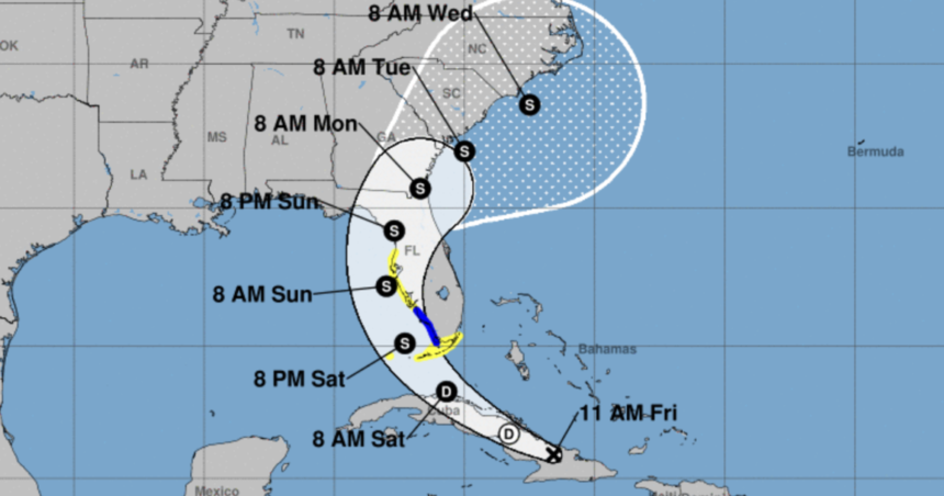
Tropical storm watches and warnings have been issued for parts of Florida as the National Hurricane Center said Potential Tropical Cyclone 4 has formed in the Caribbean.
According to the National Hurricane Center on Friday, Potential Tropical Cyclone 4 was located about 420 miles southeast of Key West, Florida, and was moving west-northwest at 16 miles per hour. The system had maximum sustained winds of 30 miles per hour with higher gusts.
Summary of Watches and Warnings in Effect:
WFTS
Tropical Storm Warning
- Southwest coast of the Florida peninsula from East Cape Sable to Bonita Beach
Tropical Storm Watch
- Florida Keys south of the Card Sound Bridge, including the Dry Tortugas
- Southern coast of Florida peninsula east of East Cape Sable to the Card Sound Bridge
- West coast of Florida peninsula north of Bonita Beach to Aripeka
A tropical storm watch means tropical storm conditions are possible within the watch area, generally within 48 hours. A tropical storm warning means tropical storm conditions are expected somewhere within the warning area in the next 36 hours.
Scripps News Tampa meteorologist Denis Phillips said the current track shows that the disturbance could make landfall on the west central coast of Florida on Sunday.
Phillips said the storm will either be a tropical depression or a tropical storm at that time. He expects winds between 40 and 50 miles per hour with higher gusts, which is similar to some of the afternoon thunderstorms that roll through Florida.
According to Phillips, there is a chance of some coastal flooding and water rise on Sunday, especially in areas prone to flooding during storms.
Phillips said the system’s timing will impact the Tampa Bay area from late Saturday through early Monday, moving from the south to the north. The system will eventually cross the state, so inland areas will also get winds.
“We get 40 to 50 mph winds many times in the summer,” Phillips said. “There could be some isolated power outages. Wind-wise, it’s an afternoon thunderstorm that will last for several hours.”
He continued, “For folks who flood along the coast, high tide could bring a bit of water as well. Water is always the trickiest part of the forecast because it depends on the angle the storm approaches our area of who sees the push and who doesn’t.”
If the system does develop into a named system, it will be named Debby.
This story was originally reported by Scripps News Tampa.


