BILLINGS — Batten down the hatches! It could be a rather bumpy Thursday.
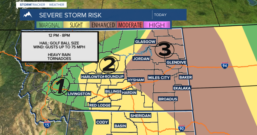
An area of low pressure sliding across the Montana/Canadian border will drag a cold front through the area today. With ample moisture coming up from the Gulf of Mexico, all the ingredients are there for multiple strong to severe thunderstorms this afternoon through the evening. We’ll put the latest timeline at 12PM to 8PM give or take an hour.
The main threats will be golf ball to tennis ball size hail and strong wind gusts up to 75 mph. Some storms could also produce heavy downpours and even a tornado or two, especially in eastern Montana down into northeastern Wyoming.
A blend of models show potential rainfall total ranging from less than a tenth to three tenths of an inch through late Friday morning. Localized rainfall totals could be higher.
The cold front pulls away on Friday, dragging cooler air in behind. Daytime highs will dip to the 60s and 70s. It will also be quite windy with gusts 25 to 45 mph possible across much of the area. This will taper off from west to east late evening as the front moves farther off to the east.
High pressure sets up for the weekend, bringing dry conditions and warmer temperatures back with daytime highs mainly in the 70s on Saturday before reaching into the 80s and maybe some 90s on Sunday.
Models indicate another trough coming in by Sunday evening, bringing more rain and thunderstorms into the area through Monday. This will also help cool temperatures back down to around seasonal Monday and Tuesday.
-Miller Robson
Q2 Morning Meteorologist
miller.robson@ktvq.com


